Spotlight on ARCHICAD 19 – Pointclouds
Tips and Tricks • Joshua Osborne • 15 June 2015
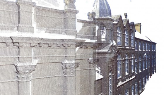
ARCHICAD 19 reads point-clouds, providing faster, error-free building surveys by using the latest 3D scanner laser-survey technology, eliminating all errors due to manual data input.
Refurbishment projects typically start with a time-consuming building-survey phase that may involve manual measurements and the creation of a digital building model. But now 3D scanners – representing the latest technology innovations – can generate “point-clouds” containing all the necessary geometry information of an interior, including its volutes and ornaments.
ARCHICAD 19 can read the most commonly used point-cloud file formats and create the corresponding 3D geometry instantly. So you can align your design with automatically-generated, 100% accurate point-cloud 3D geometry information.
This surveying workflow dramatically reduces the time spent on surveying. And it eliminates errors due to manual data input. Some typical real-life examples of how users put 3D laser survey and point- clouds to work:
- Modeling existing buildings before renovation.
- Modeling the surroundings prior to creating a new building.
- Modeling the “as-built” structure to detect deviations from plan.

The Pointcloud function will allow ARCHICAD 19 to open .xyz and .e57 file formats and convert them into native GDL‐like objects.